About SkyCharts XC EFB geo-reference
Current and valid FAA&AISWEB aviation charts updated every 28 days, including approach plates! Includes basic international airport data from ourairports.net and openAIP.net. Due to no freely avialable charts, please note...
Current and valid FAA&AISWEB aviation charts updated every 28 days, including approach plates! Includes basic international airport data from ourairports.net and openAIP.net.
Due to no freely avialable charts, please note that for charts outside of USA&Brazil non current ONC/VFR with a current openAIP overlay is available, but NO IFR charts or plates are available.
Includes a free 30 day trial!
If you wish to continue using SkyCharts after the trial, please purchase a $3.99/month subscription. Note that buying a subscription does not unlock any additional features.
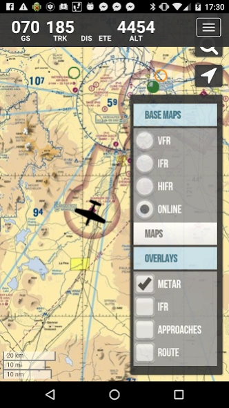
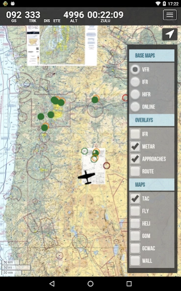
For USA/Alaska, the application has all current FAA VFR (sectional+WAC), IFR (High and Low), TAC, FLY (flip side of TAC chart), Helicopter, Gulf Coast WAC, Gulf Of Mexico, and Wall aviation charts.
Grand Canyon charts are included in the TAC charts, and Bahamas and Mexico as WAC charts.
Brazil has VFR, IFR (High and Low) and approach plates.
Also included is a METAR/TAF overlay, and an IFR overlay to view routes on top of VFR charts.
Its very easy to create and modify routes directly on the map or by drag&drop in table.
Navigation readout is configurable to fit exactly what you want to see. It also has a nifty auto-layout feature that selects fields for you in both portrait and landscape mode.
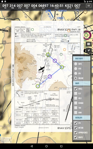
DOUBLE TAP on map to view A/FD and approach plates.
Map has VFR/IFR/LIFR color-coded weather METARs, with orange TAFs.
SUA (Special Use Airspace) information is also available.
Download charts and plates for offline usage.
Features:
* Fast zoom/scroll of included charts using standard gestures.
* Allows download of charts for offline usage. Charts are selected on a region basis.
* Navigation computes GS, TRK, DTK, DIS & ETE to final waypoint.
* METAR/TAF color coded dots according to ADDS: http://www.skycharts.net/?page_id=421
* Double tap on airport to select A/FD and TPPs/IAPs to view.
* Huge built-in navigation database, with all 20,000 airports, 45,000 FAA IFR/VFR navigation fixes and 2,100 FAA VOR/ADF fixes.
For more information, please see the webpage at
http://www.skycharts.net
The monthly subscription of SkyCharts XC aviation data of $3.99 is auto-renewed. Payment will be charged to your Google Play Store account at confirmation of purchase. You can turn off auto-renew at any time from your Google Play Store account settings, but you must do so at least 24 hours before the end of the current subscription period to avoid being billed for the next cycle. No cancellation of the current subscription is allowed during the active period. Any unused portion of a free trial period will be forfeited when you purchase a subscription to SkyCharts XC.
The privacy policy and EULA can be found here:
http://www.skycharts.net/?page_id=1465
For fast response to all questions, comments or suggestions, please email
[email protected]
Previous Versions
Here you can find the changelog of SkyCharts XC EFB geo-reference since it was posted on our website on 2016-10-11 12:53:48.
The latest version is 5.5.0 and it was updated on 2024-04-19 18:33:10. See below the changes in each version.
SkyCharts XC EFB geo-reference version 5.5.0
Updated At: 2023-11-03
SkyCharts XC EFB geo-reference version 5.4.8
Updated At: 2020-08-07
Changes: Minor bugfixes
SkyCharts XC EFB geo-reference version 5.4.7
Updated At: 2020-07-22
Changes: Built in 2008 database
Fix for blank screen on launch
SkyCharts XC EFB geo-reference version 5.4.6
Updated At: 2019-09-04
Changes: Android 9 support
1909 database
SkyCharts XC EFB geo-reference version 5.4.5
Updated At: 2018-05-23
Changes: *Bugfix for user defined waypoint
*You can now download the A/FD and approach plates on an airport basis! When used in conjunction with 'Charts only' option you can get away with downloading half the amount of data compared to previous versions. Note: obviously you then have to make sure all the airports you intend to use have been downloaded!
SkyCharts XC EFB geo-reference version 5.4.1
Updated At: 2018-03-02
Changes: *More international data
*New openAIP layer
*Built in 1803 database
SkyCharts XC EFB geo-reference version 5.1.0
Updated At: 2016-09-16
Changes: Built in 1610 database,Easier to add route on smaller devices (moved +route all the way to the left).
Disclaimer
Official Google Play Link
We do not host SkyCharts XC EFB geo-reference on our servers. We did not scan it for viruses, adware, spyware or other type of malware. This app is hosted by Google and passed their terms and conditions to be listed there. We recommend caution when installing it.
The Google Play link for SkyCharts XC EFB geo-reference is provided to you by apps112.com without any warranties, representations or guarantees of any kind, so access it at your own risk.
If you have questions regarding this particular app contact the publisher directly. For questions about the functionalities of apps112.com contact us.